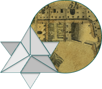
Contenuti descrittivi

Introduction

Introduction

The map of Latisana by Antonio Banchieri was drawn in 1834. The year is shown on the right under the drawing.

Icona dell'Introduzione

On top, in the middle, is the title LATISANA, name also shown in the form LATISANAE on the left under the drawing.

From a cartographic point of view it is a reinterpretation of numerous surveys made by public experts hired in the eighteenth century by the noble consortium members of the Land of Tisana. It takes up in particular the survey of the expert Antonio Antonelli of 1746 on the illustrious families of Latisana.

Read more

Insight

Seven sheets of different sizes make up the plan of Antonio Banchieri. They were assembled and adhered to the raw canvas on a wooden frame (62 x 83 cm). The canvas and some fragments of paper are fixed along the edges with metal nails. In the middle is Latisana of the past, with the commercial activities of the Port in the Middle Ages. The Banchieri family was originally from Feltre.The surname suggests that their ancestors were bankers, possibly of Jewish origin. He is not an artist by trade, but perhaps a local enthusiast or a lawyer, a lover of poetry and art.

Bancheri takes up a survey of the expert Antonio Antonelli of 1746, who intends to fix the boundaries and draw up a cadastre to estimate the value of the land. Compared to Antonelli's drawing, preserved at the Joppi Civic Library in Udine, there are some differences related to the period and purpose. Banchieri, in fact, reports the vitality of the places with meticulous details and characters. Also by Antonio Antonelli is the map that shows the Braida called Brolo in Rocca di Cà Capello, with the convent of the nuns and the Rocca. This map is published in Storia e Arte del Septifanium di Latisana (History and art of the Septifanium of Latisana) by Vinicio Galasso, Latisana, 2010, p. 156.

A subsequent topographic map of Latisana, edited by G. B. Garlato, shows the ancient bed of the Tagliamento River and the line up to where the houses were. Along Borgo Rocca and the square the arcades are marked. Behind the building indicated as Casa Gazzola (no. 25 in the plan of Banchieri) the ancient Rocca, not present in the map of Banchieri, is depicted. The map of Garlato is published in Latisana e il suo distretto. Notizie storiche, statistiche ed industriali (Latisana and its district. Historical, statistical and industrial news), Venice, 1858.

Representation

Introduction

The map of Latisana by Antonio Banchieri allows the comparison between the urban layout of the past and Latisana of today. The drawing depicts a bird's eye view of Latisana with its streets, palaces and activities.

Icona della Rappresentazione

The buildings and annexes are rendered through the representation of the views and the topographic representation. The numbers from 1 to 60 refer to the key, shown below the drawing.

Among the streets, on rafts or boats along the river Tagliamento some people are depicted.

Lei di plui

Insight

In the representation there are numerous examples of spontaneous architecture and Venetian influence. In addition to the noble palaces there are peasant houses with external stairs and thatched roofs and farm buildings with large arches. Some buildings have truncated cone-shaped chimneys typical of the city of Venice and the lagoon. Great care is also paid to the representation of gardens, internal courtyards and vegetable gardens. The depth is rendered through black backgrounds. In some cases the shadow on the ground is more pronounced. Darker colored strokes are used for river water.

People on the banks of Tagliamento river

Near the riverbank, just beyond the Pass (6), there is a raft carrying barrels. Some sailors are on board a two-masted boat, probably a tartana, moored with rolled sails and with a boat tied to the bow. At the Pass (6), in the middle of the river, a cart with horses is transported. The barge is driven by the passador, who is operating the rope for crossing from one bank to the other. A boat with a square unfurled sail is carrying goods and sailing along the river on the left side of the map. On the other bank, near Ca' Mocenico (3), some people are on board a small boat. This is a secondary pass. Beyond the Pass (6), near a raft carrying three barrels and large lumberyards on the bank, a man with a stick and a basket on his shoulders is conversing with another person. The man is wearing trousers and socks, a jacket and a wide brim dark bowler hat. A little further on, two rafters are carrying a rustic wagon on a raft with four wheels. A third person is on land near the berth.

People in the streets among animals

On the square (37) two people are walking near the Church of S. Croce (38): one is wearing dark clothing, the other one light clothes. They are carrying umbrellas and dark, wide-brimmed hats. Near the Church of S. Croce (38) a coachman is driving a carriage pulled by a pair of horses. Just beyond the Piazzetta (48), a woman with a saucepan in her hand is standing near a wooden quay on the river. Near the Pass (6), a man and a woman are carrying a wooden yoke on their shoulders with two buckets for water. Below, near the entrance to the Church of S. Michiele (5), there is a man and a woman. Along the Strada della Sabbionera (10) there are two people with long light clothes; they seem to be of oriental appearance for some features of clothing. Near them, on the Strada della Sabbionera (10), a dog is depicted. In the park of Ca' Mocenico (3) there are two peacocks.

Key

Introduction

The bottom part of the map shows a handwritten key. Each number, from 1 to 60, is linked to a place or a building on the drawing.

Icona della Legenda

The key is preceded by a writing that shows the name of the author, Antonio Banchieri.

EX TOPOGRAPHICO ICONE MDCCXLVI ANTON BANCHIERIUS AD ARTIS FORMAM REDEGIT ET PINXIT (From a topgraphic drawing of 1746, Antonio Banchieri riproduced in art form and painted).

The numbers from 1 to 60 follow, divided into 10 columns.

Read more

Insight

FIRST COLUMN: FROM 1 TO 6
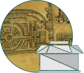
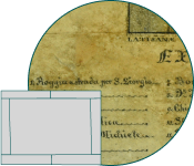
1. Roggia e strada per S. Giorgio (Canal and road for S. Giorgio)

Now provincial road 73.

2. Donacis

Family attested from the XVII century.
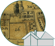
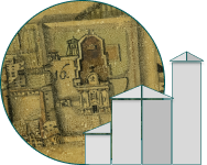
3. Ca' Mocenico

An old judicial family whose palace was already in place in 1599. To the right and left of the building there are two barchesse of the seventeenth century, attributed to the architect Baldassare Longhena.

4. Public road

Currently Via Carlo Ivancich.

5. Church of San Michiele

A church dedicated to St. Michael is attested in 1518. In the twentieth century a new parish church was built on the site of an older church. Damaged during the First World War, it was destroyed during the Second World War.

6. The Pass

The Pass is the crossing point of the Tagliamento river from one bank to the other for the transport of people, animals and goods.

SECOND COLUMN: FROM 7 TO 12
7. Bonis

A so-called family is attested in Latisana in the XVII century.

8. Tagliamento River

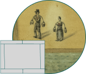
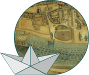
It is the most important river in Friuli and has marked, for better or for worse, the life of Latisana. The map by Antonio Banchieri gives the opportunity to observe the liveliness of the activities of the ancient river port of Latisana, documented since 1226.

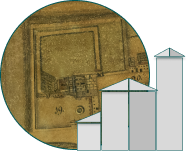
9. Church and Convent of the Reverend Fathers of S. Antonio Sab.

The Church and Convent of the Reverend Fathers of St. Anthony, called the Church of S. Maria della Sabbionera and later the Church of the Beata Vergine delle Grazie (Blessed Virgin Mary of Graces), was built in 1578. The adjacent Franciscan convent was founded in 1638 at the request of Fra Vincenzo Mocenigo.

10. Strada della Sabbionera (Road of the Sabbionera)

The name Sabbionera is attested in 1519. It refers to lands or to an area with mainly sandy and dark-coloured land.

11. Suzzi Factories

The term factories should be understood as buildings. The Zuzzis were originally from San Michele. In the eighteenth century they had the title of Count of Roverbasso and Restegliuzza by the Republic of Venice.

12. Valentinis

An old judicial family: the Valentinis of Latisana (early XVII century) were a branch of the Valentinis originating in Aquileia and transplanted to Udine in the XIII century. They owned property and a manor house in Ronchis and Venice. They had a seat in the Consortium of noble judges of the fief of Latisana.

THIRD COLUMN: FROM 13 TO 18
13. Borgo di Sottopovolo (Village of Sottopovolo)

Sottopovolo litterally means “under the poplar” (from the Venetian povolo, poplar) and it recalls the custom of heads of families gathering under a poplar in the Middle Ages. It was a rural administrative municipality separated from the Port of Latisana. Named in 1546, it developed along the current Via Sottopovolo.

14. Public Loggia

It was the building in which the assembly of heads of families met, the vicinia, to decide on the various administrative matters of the municipality. It was the seat of the Municipality in the Austrian period until 1897.

15. Strada dietro Chiesa (Road behind the Church)

Its name is very old. In a document of 1547 the place is indicated as Post Gesia. Later it will become In loco dopo chiesa, Drio Chiesa di S. Zuanne, Drio Chiesa, Drio Cesa.

16. Parish Abbey Church of S. Gio.ni Bat.ta and Can.ca dell'Abbate (Abbot Vicarage)

The first testimony of the Parish Abbey Church of S. Giovanni Battista and Abbot Vicarage dates back to 1368. In 1504 the church was completely remodeled. Around 1750 it was renovated by the Lombard architect Luca Andrioli.

17. Public Road of Ronchis

It is the current Via Egregis Gaspari dedicated to the noble Rosa de Egregis, widow Gaspari, who died in 1888. She left a substantial donation for the foundation of the nursery school, now a kindergarten, which bears her name.

18. Contrada of Osoppo

The contrada was located near the current Piazzale Osoppo. Its name appears in 1573 referring to the whole suburb: In Osophio portus Latisanae. It is also mentioned in Friulian: Braida in Osôf.

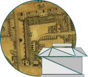
FOURTH COLUMN: FROM 19 TO 24
19. Church and Convent of the R.R.e M.M. di S.n Antonio (Most Reverend Mothers of St. Anthony)

The history of the Church of St. Anthony of Padua, built by the will of the patron of Latisana Gasparo Morossi, until 1810 is intertwined with that of the Monastery or Convent of the Franciscans. In 1733 the monastery was cloistered. The citizens of Latisana have always had a lot of affection for this place of worship.

20. Borgo delle Monache (Village of the Nuns)

The village was located along the current Via Carlo Goldoni. The name, until the end of the nineteenth century, is due to the fact that it led to the Church of St. Anthony of Padua, annexed to the convent of the Franciscan nuns.

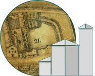
21. Church and Convent of the R.R.i PPi di S. Ago.no (Most Reverend Fathers of St. Augustine)

The church of S. Antonio Abate and the Augustinian convent are attested in 1466 and 1486. The convent was founded in the early eighties of the fifteenth century by the will of the couple Zaccaria Vendramin and Chiara Capello. In 1769 the convent was suppressed by the Venetian Republic and immediately afterwards used for civil uses. In 1806 the church was used as a warehouse. The complex, sold to the Gasparis, was destroyed by fire in 1917.

22. Borgo di S. Antonio (Village of St. Anthnoy)

The village is attested in 1572: In burgo S. Antoni versus porta Sancti Ioanis. The door of S. Antonio was one of the two gates that allowed access to the medieval village, at the end of the current Via Vittorio Veneto. The other door, of S. Giovanni, was located between the beginning of Via Vendramin and Piazza Garibaldi.

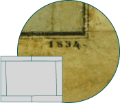
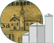
23. Strada della Annunziata (Road of the Annunciation)

It is the current Calle della Annunziata, attested in 1835 as Strada com. dell'Annunziata. The name takes up the presence of a church dedicated to Our Lady of the Annunciation. Dating back to 1657, it was suppressed at the beginning of the '900

24. Casa Colonna (House Colonna)

It is a Roman patrician family, attested in Latisana in the XVII century.

FIFTH COLUMN: FROM 25 TO 30
25. Bovaria Cappello

The term Bovaria, from boarìa, indicates a large farm. The Cappellos were a Venetian patrician family. In Latisana they are attested in the eighteenth century

26. Borgo di Rocca (Village of Rocca)

The village was located along the current Via Rocca. It is attested in 1543 In loco dicto la de la Roccha. Rocca was the name given to a tower built in the fourteenth century to defend the town of Latisana. It was located approximately at the end of the current Via Rocca. It was destroyed at the beginning of the sixteenth century.

27. Canevon

Canevon is a term that in Venetian indicates a large cellar.

28. Zaffi

The name of this building may refer to the Zaffi family, whose surname is widespread in Tuscany and Emilia Romagna, or to the residence of the zaffi, the guards at the service of the feudal court. They are named in a trial of the Inquisition that took place in Latisana in 1591.

29. Ca' Minotto

Venetian patrician family who had feudal possessions in Latisana. It was part of the Consortium of Jurists in the eighteenth century.

30. Ca' Molin

Venetian patrician family, present in Latisana in the seventeenth century. It was part of the Consortium of Jurists. Palazzo Molin, then Molin Pittoni Vianello, dates back to the seventeenth century.

SIXTH COLUMN: FROM 31 TO 36
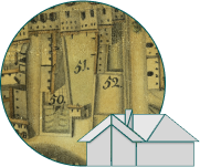
31. Taglialegne

Family attested in Latisana in the XVII centrury. In 1810 the palace of the Vendramin family was bought by Santina Renso-Taglialegne.

32. Cà Bernardo

Venetian patrician family present in Latisana in the Consortium of Jurists in the XVI century (1585).

33. Donatis

Donatis or Donati: family originally from Orio, of Bergamo. It is attested in Latisana in the XVIII centrury.

34. Caprilio

Caprilio or Caprileo: family attested in Latisana in the XVI century. They were lawyers and notaries.
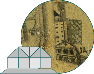
35. Morossi

Family maybe originating from Venzone and settled in Latisana around 1500. The members of this family were jurists, lawyers and notaries.

36. Canelle

At the moment we do not have news about this family. Their surname is mainly spread in the in the Veneto-Emilian area.

SEVENTH COLUMN: FROM 37 TO 42
37. La Piazza (the Square)

It is the current Piazza Indipendenza. Until the early nineteenth century it was simply called la Piazza (the Square).. At the end of the nineteenth century it was called Piazza Maggiore, then Piazza XX Settembre and then Piazza Roma. The current name dates back to the post-Second World War.

38. Church of S. Croce (St. Cross)

The Church of Santa Croce, now disappeared, is attested in 1310. On 16th October 1368 the oath of loyalty of the people of Latisana to Mainardo Count of Gorizia took place here. It was demolished in 1776 together with the adjacent Ospedale dei Poveri (Hospital of the Poor), dating back to the sixteenth century.

39. Capitanio

It is the house where the Captain governor of the fief of Latisana lived. It is named, with its cortivo (courtyard) and garden, in the act of division of the Vendramin brothers of 1528.

40. Grotti

Venetian family attested in Latisana in the XVI century (1591).

41. Zoccolari

Friulian-Venetian family attested in Latisana in the XVIII century.

42. Lavezari

Family present in Latisana in the XVII century.

EIGHTTH COLUMN: FROM 43 TO 48
43. Corradini

Old Venetian family present in Latisana in the XVIII century.

44. Cagnolini

Family attested in Latisana at the end of the XVI century. Noble family of Veglia. Its members were devoted to pharmacy and medicine. They are active as apothecaries even in the eighteenth century.

45. Grotto

Venetian family. They are attested in Latisana in the XVI century.

46. Cà Contarini

Venetian patrician family. They appear in Latisana as Jurists in the XVII century (1658).

47. Cà Benzon

The Benzon were a Venetian patrician family. This is the palace of the Vendramin family, brought as a dowry to the Contarini in 1644 and to the Benzon in 1700. The Venetian palace, now Palazzo Trevisan, was destroyed by bombing in 1944.

48. Piazzetta

Annex of the Square, it went between Palazzo Vendramin and Casa Cappello, up to the Tagliamento river. It is currently called Via del Battello

NINTH COLUMN: FROM 49 TO 54
49. Cà Cappello

Manor House of the Cappellos, Venetian patrician family. In Latisana they are attested in the XVIII century.

50. Tomasini

Family present in Latisana in the early XVIII century.

51. Abbot Morosso

House belonging to the abbot Agostino da Latisana, Carlo Morossi (Latisana 1629 - Venice 1713).

52. Beccaria

Building uses as a slaughterhouse.

53. Osteria Matassi (Matassis' Inn)

Osteria dei Matassi, family present in Latisana in the XVII century.

54. Ghetto

Building where the Jews lived in Latisana, permanently present from the XVI to the XVIII century. More than a ghetto we can speak of a giudecca in Latisana, or the delimitation of an area where the Jews resided for reasons of security and not of imposition.

TENTH COLUMN: FROM 55 TO 60
55. Dall'Acqua

At the moment we do not have precise information on this family.

56. Rossetti

Family present in Latisana in the XVI century. In the writing the R is not visible any longer.

57. Bianchini

Family present in Latisana in the XIX century.

58. Fontanini

Family present in Latisana in the early XVII century.

59. Amadi

Family present in Latisana in the XVIII century.

60. Pinzani

Family present in Latisana in the XVII century.

Restauration

Introduction

Type of intervention:

restoration and conservation intervention

Times:

June - August 2022

Restorers:

Loredana Soranzio, Caterina Longo and Adriano Macchitella from the Centro Studi e Restauro Soc. Coop of Gorizia.

Icona del Restauro
Conditions prior to restoration:

over time the drawing has been affected by the leaching of pigments especially in the upper right part and by the attack of xylophagous insects near the margins. Along the upper margin and near the lower right corner there was a tear and a small breakthrough of the paper support.

Intervention:

cleaning, removal or stabilization of the paint, consolidation and integration were carried out. The canvas has not been detached from the frame to avoid deformation of the sheets and loss of pigments.

Conservation after restoration:

the drawing has been inserted in a new floating frame with upper glass that leaves the edges of the original frame visible.

Read more

Insight

The map of Latisana by Antonio Banchieri, before the restoration, was inserted inside a nineteenth-century wooden frame with cut glass, hung on the wall in the office of the Mayor of the Municipality of Latisana. The restoration work was carried out between June and August 2022 by the Centro Studi e Restauro Soc. Coop of Gorizia. A first photographic documentation of the state of conservation was followed by the opening of the frame and the analysis of the work. The paper support had undergone a browning over time presumably due to the use of adhesive of animal origin to adhere the sheets of paper to the canvas. In addition, a paint had been spread on the sheet. The drawing, when observing in particular the upper right portion, had been in contact with liquid substances that had determined the loss of brilliance and chromatic tone. The paint had completely washed away and accumulated in the center of the drawing, where it had caused a dark stain. This support part also had “gore” (stains). Excess moisture may have caused the paint present throughout the design to deteriorate generally. The paint has cracked during drying, leaving visible widespread deficiencies on the paper support.

Specifically, a dusting with a soft brush and a dry cleaning was carried out both on the paper support and on the canvas. Maximum attention has been paid to pigments and the most fragile parts, especially near weakening and cracking. The intervention of rehydrating the pictorial surface with a water-based solution has allowed to carry out the subsequent application of the paint and pigments in the sections of support already uncovered. The operation was repeated where necessary until perceptual homogeneity was attained. The browning in the central part was mitigated. A methyl hydroxyethyl cellulose 300p-based adhesive was used in different percentages in aqueous solution, spread with the tip of a retouching brush. In addition, localized fixation of pigments on the legend and consolidation of fragile areas attacked by xylophagous insects was performed. For the tears and breakthroughs present, veil and Japanese paper of suitable colors and grammage were used. Accurate watercolor integration was made in sub-tone in correspondence with the restauration made with Japanese paper and in areas with perceptual continuity defects. From the analysis it was possible to understand that the small lighter areas of the drawing correspond to white spots of lime caused accidentally. The small fragments of tissue paper along the edge have been retained as they are considered an integral part of the history of the document. This would perhaps not be a recent tracing. The canvas has a structural function in keeping together the seven sheets that make up the plant. It has not been detached from the frame to avoid deformation and the possible loss of pigments.

When the restoration was completed, the drawing was inserted in a new floating frame with museum glass that leaves the margins of the original frame visible. Given the fragility of the document, the Superintendence has prescribed that the map is no longer permanently exposed to avoid damage caused by light. Scholars can consult it, upon motivated request to be presented to the Town Library. To give back the restored image of the map to the public, on the first floor of the Town Hall of Latisana, a color reproduction in 1:1 scale is exhibited on photographic paper inserted in the nineteenth-century frame. The frame has been previously cleaned, consolidated and wax-polished.

Bibliography

Introduction

Numerous publications report the map of Latisana by Antonio Banchieri in its entirety or some details.

Icona della Bibliografia
  • M. G. B. ALTAN, Latisana e le sue origini marinare, Latisana 1985
  • M. G. B. ALTAN, E. FANTIN, V. FORMENTINI, Pieve abbaziale di Latisana. Cenni storici, Latisana, la bassa 1994
  • M. G. B. ALTAN, La Serenissima a Latisana 1420-1797. Dai Conti di Gorizia a Napoleone, la bassa 2001
  • L. CICERI (a cura di), Tisana, Società Filologica Friulana 1978
  • F. DONATI, Quadro storico delle vicende politico-commerciali e morali di Latisana e dell'attuale suo fisico stato (1807), la bassa 1982
  • E. FANTIN (a cura di), Latisana appunti di storia, la bassa 2010
  • V. GALASSO, Latisana dalle origini al duemila, Latisana, la bassa 1999
  • V. GALASSO, Storia e Arte del Septifanium di Latisana, Latisana 2010

Read more

Insight

Further bibliographic sources:

  • Comune di San Michiele al Tagliamento 1807-2007, San Michiele al Tagliamento, Municipality of San Michele al Tagliamento 2007
  • Dante canta Latisana, video recording made as part of the project "Un anno con Dante", C. BRUGNETTA [director], A. FLORAMO [historical analysis], D. DE GREGORIO [musical improvisations], Latisana, Municipality of Latisana 2021, [DVD]
  • E. FANTIN, Il santuario della "B.V. delle Grazie" di Sabbionera. Le origini e la sua storia, Latisana, la bassa 1996
  • E. FANTIN, La Signoria dei Vendramin nella Terra della Tisana: Un anticipato interesse di Venezia per il Friuli, “la bassa”, 81 (2020), pp. 29-64
  • V. GALASSO, Perle d'arte, Latisana, Municipality of Latisana 2016
  • Latisana e il suo distretto. Notizie storiche, statistiche ed industriali, Venezia, Tipografia del Commercio 1858 (anastatic reprint Latisana e il suo distretto, Udine, Ribis 1979)
  • Latisana il Segno e il Tempo, Latisana, Municipality of Latisana 2001
  • M. MONTE, Ebrei e banchi ebraici nella “particolare giurisdizione della Tisana” in età feudale, “la bassa”, 45 (2002), pp. 29-44
  • V. ROGATO, F. ROMANIN, N. TRACANELLI, San Michiele la “Cassino del nord”, Latisana, la bassa 1996
  • D. SCIUTO, La pala del Veronese nella pieve abbaziale di Latisana, Latisana, Municipality of Latisana 1995
  • Catalog cards Regional Information System of Cultural Heritage of Friuli Venezia Giulia (SIRPaC)
  • R. TIRELLI (a cura di), Una giudecca a Latisana. Mappa, storie, tradizioni, Proceedings of the Conference (Latisana, 4 September 2022), Latisana, Municipality of Latisana 2023
  • A. ZANNINI (a cura di), Un paese, un fiume. Storia di Latisana dal Medioevo al Novecento, Udine, Forum 2020

Ghetto

Introduction

Number 54 of the map shows the writing “54. Ghetto” in the key. It was a small family-sized Jewish settlement.

Icona del ghetto

It was a house or cluster of huts in front of the Church of S. Giovanni Battista (St. John the Baptist) (16).

Banchieri depicts a two-floor building on the street front with an arched access door and an internal courtyard at the back. There resided the Jews, permanently present in Latisana from the sixteenth to the eighteenth century, with the pawnshop. The façade has undergone some changes over time: the portal, which today opens onto an internal courtyard garden, is no longer arched. The building may have been raised if we compare the fronts of the block on the main street with the depiction of Banchieri, which shows the same height for the different buildings.

Read more

Insight

In Latisana we can speak of a Giudecca rather than a Ghetto, since it is a space where the Jews resided for reasons of security and not of imposition. The first Jewish settlements in Latisana date back to the first half of the '500. They are probably Jews of Ashkenazi origin, from Central and Eastern Europe. In 1302 a Jew, Isak of Lienz, collected taxes for the Counts of Gorizia who then owned the fief of Latisana. In the sixteenth century in Latisana Jews carry out activities of money changers and money loan, without however residing in the fief.

The Vendramin family, who succeeded the Counts of Gorizia after some changes of ownership in 1457, guaranteed the Jews a certain autonomy in compliance with rules and conduct, a space to reside and an environment to exercise the loan. In Latisana the Jews make an economic and cultural contribution. They also practice professions not usually granted to them such as wheat cultivation, cattle breeding and viticulture. A document of 1528 reports a duty of seven lire due by the butcher or "kosher" butcher shop of the Jews and in 1574 the presence of a Jewish doctor is attested. The great mobility linked to the port implies a certain mixture between local people and foreigners. Relations with the population are mostly of coexistence and confrontation.

As some documents attest, Jews did not always live in this building. The Jewish presence in Latisana ended in 1746 and the small community dispersed or became extinct. In 1748 the house indicated as "54. Ghetto", rented to the Jews by Francesco Barbarico, is empty and in 1810 the owner is Antonio Paolini. In the attic of the building, today Corte Chiarcos, several years ago some objects related to Jewish culture were found. In 2020 an epigraph was placed the entrance hall, that shows the presence in the court of Jewish units with pawnshop.

Ca' Mocenigo

Introduction

Number 3 of the map bears the writing "3. Ca' Mocenico" in the key. The palace already exists in 1599 in San Michele.

Icona di Cjase Mocenigo

Banchieri depicts the noble palace on the bank of the Tagliamento river with two symmetrical “barchesse” (barns) on the sides and a large park, surrounded by walls and a monumental gate.

The palace has a portal in the middle with an upper semicircular element, large openings on the first floor and perhaps above the coat of arms of the family. On the roof a statue is located in the center and two inverted truncated conical chimneys are at the ends. The two barns have six arches on the main front and two gabled ones on the side fronts. A high frieze is punctuated by oval windows.

After the Second World War and the earthquake in 1976 only the two ruined barns, some adjacent buildings and the park remain of the complex, now Biaggini Ivancich Estate.

Read more

Insight

The Mocenigo are part of the Venetian patrician families that in the late sixteenth century form the Consortium of Jurists of the feud of Latisana. Ca' Mocenigo happened to be already built in 1599 during the marriage between Marcantonio Mocenigo and Bianca Vendramin. Located near the Port on the Tagliamento river, it presents a site layout typical of sixteenth-century Venetian villas. The vermilion plaster that gave the name of Palazzo Rosso, is later replaced by white marmorino plaster finish.

Two barns, conceived as perspective wings, frame the main building. Built to house the work and service environments of the peasants, they date back to the seventeenth century and are attributed to the architect Baldassarre Longhena (1598-1682). Two other names of architects have been hypothesized: Francesco Contini (1599-1669) and Giuseppe Sardi (1624-1699). The main front is punctuated by seven arches on rectangular pillars interspersed with Doric-Tuscan semi-columns. They support an entablature with a high frieze, punctuated by triglyphs surmounted by heads with animal elements and elliptical windows with a cartouche-style frame.

After a period of neglect, the palace is renovated in 1870 by Vincenzo Biaggini. It is later passed to the Ivancich and hosts famous people including Ernest Hemingway. During the First World War it is used as a field hospital of the Italian Red Cross and it is then used by the Austro-Hungarian command. During the Second World War the villa is bombed. All that remains of the 18th-century complex today are the two ruined barns and the chapel of San Giuseppe (St. Joseph), perhaps added to the south barn in the mid-eighteenth century. In the park there are eight eighteenth-century statues depicting the seasons and four virtues.

Ca' Molin

Introduction

Number 30 of the map shows the writing “30. Ca' Molin” in the key. A Venetian patrician family, they are in Latisana in the seventeenth century.

Icona di Ca' Molin

The building, called Ca' Molin and then Molin Pittoni Vianello, dates back to the seventeenth century.

Banchieri depicts a three-floor building consisting of a central building, of greater height and tympanum, and two symmetrical bodies on the right and left. These are punctuated by four windows on the upper floor and three circular arches on the ground floor. On the back there is an internal courtyard. The central body has five circular arches on the ground floor. In the center there is a three-mullioned window on the upper floor with circular arches, perhaps a coat of arms, two windows and a gabled dormer with three summit statues.

Read more

Insight

The Molins were part of the feudal and patrimonial landowners in the patrician fief of Latisana, in whose Consortium they appear as judges. Looking at the relief by Antonio Antonelli of 1746, the building on the left has no arches on the ground floor and you can see only two windows on the upper floor. Banchieri instead shows three circular arches on the right and left, marking the central building with an angular ashlar. Today the street fronts no longer have circular arches on the ground floor.

At the tympanum and along the pitches of the roof 12 statues representing the months of the year were removed. In the center, above the rectangular stone portal, there is a three-mullioned window with circular arches and wrought iron balustrade. Aligned, there are two windows with a balustrade and tympanum dormer. Inside, on the first floor, there is the "Sala Stucchi". Numerous plaster frames contained works that had been lost along with the original furnishings following the looting of the Napoleonic era and the Austrian occupation during the First World War.

In the fifties of the twentieth century the ground floor was home to the post offices and later furniture storage for a shop. It was purchased by the Municipality of Latisana in the late sixties with the project, then implemented only for a short period, to transfer the Public Library there. Currently the central body houses the Pro Latisana Association, the Municipal School of Music and the Tourist Information Office.

Morossi

Introduction

Number 35 of the map reads “35. Morossi”. Morossi (Palace Morossi), dating back to the eighteenth century, is the current seat of the Town Hall.

Icona di Palazzo Morossi

A family perhaps originally from Venzone, settled in Latisana around the sixteenth century. Several members of the Morossi family were jurists, lawyers, notaries and chancellors of the Venetian feudal jurisdiction in Latisana.

Gasparo Morossi, who lived between 1589 and 1660, was a wealthy timber merchant and father of the Franciscan friar Agostino from Latisana.

Read more

Insight

The building today has a round arched stone portal in the center with a voluted keystone and a cornice on top. Above there is a balcony overlooked by a mullioned window with circular arches. The palace has architectural elements and an internal layout of the typical rooms of Venetian palaces. It was remodeled in the eighteenth and nineteenth centuries. A bronze plaque was placed in 1900 in memory of King Umberto I. On the ground floor, on the right, in the first half of the twentieth century there was the Caffè Restaurant Centrale, then Caffè Veronese.

In the middle of the balcony there is still today the coat of arms of the Municipality of Latisana. It has two rampant lions facing a tower with double Guelph battlements; at the bottom there is the inscription Tisana. The lion refers to the coat of arms of the Counts of Gorizia, feudal lords of the Land of Latisana for three centuries. It is a matter of reviving elements present in the fourteenth-century seal of the Municipality of the Port of Latisana. The ancient seal, in fact, bears a tower with Guelph battlements in the center and is flanked by two shields that show a rampant lion facing the tower inside. Above the coats of arms there are two crosses. At the edges of the circle runs the following inscription: SIGILUM COMUNIS PORTVS LATISANE.

Ca' Benzon

Introduction

Number 47 of the map shows the writing “47. Ca' Benzon” in the key. The palace is that of the Vendramin family (46 and 47), passed as a dowry to the Contarini and Benzon.

Icona di Ca' Benzon

Venetian patrician family, who became part of the Consortium of Jurists of the Land of Tisana in 1743.

Banchieri depicts a three-floor building with a rectangular portal on the ground floor in the center. The upper floor has a three-mullioned window with balustrade in the center between two circular-arched windows.

Read more

Insight

The Land of Tisana, fief of the Counts of Gorizia from the twelfth century, in the fifteenth century passed under the dominion of Venice. The Vendramins became its owners in 1457. They promote agriculture and introduce the breeding of a beautiful breed of horses. The largest revenue comes from the collection of duties. Bartolomeo Vendramin was succeeded by his son Zaccaria, who in 1528 pass on the fief of Latisana to his three sons Nicolò, Andrea and Zaccaria. In the late sixteenth century the fief is divided between patrician families, united in the Consortium of Jurists. The Vendramins leave a tangible sign of their presence with charitable works and bequests.

The palace, with a courtyard and vegetable garden, was bought by Zaccaria Vendramin in 1510. It already existed in 1528 and presented, on the main floor, a large hall that opened onto the square with a loggia. It repeats the traditional scheme of the Venetian palace with a tripartite structure on the façade and a series of large openings in the central part, at the hall. Historical photos show a four-light mullioned window with circular arches in the center of the main floor. On the column of the loggia the ordinances of the Jurists and the Captain were posted. In the seventeenth century the attic of the building was used as a prison.

In May 1644, with the marriage between Isabella Vendramin and Giacomo Contarini, the palace passed as a dowry to the Contarini, a Venetian patrician family. In 1700 it passed to the Benzon family following the marriage between Lucina Contarini and Pietro Benzon. Some restorations and the realization of the stuccoes of the salon date back to this phase. In 1810 the palace was bought by Santina Renso-Taglialegne, in 1889 it was inherited by her son Marzio and in 1934 it became the property of Peloso Gaspari. During the Second World War it was destroyed by bombing; in its place Palazzo Trevisan was built. The building, designed by architect Pietro Zanini from Udine, respects the volume of the ancient palace.

Abate Morosso

Introduction

Number 51 of the map shows the writing “51. Abbate Morosso” (Abbot Morosso) in the key. This is the house that was owned by Abbot Agostino from Latisana

Icona di casa Abate Morossi

Agostino from Latisana, born Carlo Morossi, was the son of Gasparo Morossi and Elisabetta Gordino.

Banchieri contrassegna con il numero 51 due facciate sulla Piazza (37) e una corte retrostante.

Read more

Insight

Carlo Morossi was born in Latisana on 5th February 1629. He entered the Order of Friars Minor Capuchin in Conegliano in 1646, was lecturer in philosophy and theology, vicar, guardian and superior of the Province in 1672, 1678 and 1684. In 1702 he became Minister General of the Order. He died in Venice on 4th January 1713. His father, Gasparo Morossi, was a wealthy timber merchant. In 1659 he had indicated in his will a legacy for the construction of the main altar of the Church of St. Anthony of Padua (19) and for the construction of the adjacent monastery of the nuns.

The palace dates back to the eighteenth century and today overlooks Piazza Garibaldi, where once there was a vegetable garden. It has a long and elegant façade with a central arched portal in smooth ashlar blocks. Above the portal there is a three-mullioned window with stone frame and a wrought iron balustrade. In the center, immediately above, there is the coat of arms of the noble family: a Molosso dog at the foot of a tree. Three smaller windows with stone frame are located, in axis, on the top floor. To the right and left of the portal there are commercial spaces (shops) on the ground floor and three windows on the upper floors. One side of the building overlooks the Tagliamento river, the others develop around a central courtyard.

Public Loggia

Introduction

Number 14 of the map shows the writing “14. Loggia Pubblica” in the key. It was the building where the vicinia, the assembly of the heads of families, met.

Icona della Loggia Pubblica

The vicinia met at the sound of the bell to decide on various administrative problems according to the customs of the community.

In the map by Antonio Banchieri the façade recalls classical forms. It is divided into two orders of overlapping loggias with three large arches, with rounded arches on the ground floor and on the upper floor. At the top, above the architrave, the triangular tympanum has a circular opening in the center.

Read more

Insight

The building, also called Loggia of the Municipality of Sottopovolo, was located at the crossroads of the current Via Sottopovolo and Dietro Chiesa, near the Church of S. Giovanni Battista (St. John Baptist) (16). The Captain's proclamations were affixed here. The term Sottopovolo means "under the poplar", from the Venetian povolo, poplar. It recalls the custom of the heads of families in the Middle Ages to gather under a poplar. Sottopovolo was once a rural administrative municipality separated from the Port of Latisana. It had jurisdiction outside the Castrum (the castle locally known as Rocca), where the landowners and artisans (Lords and Artists) resided. The vicinia elected two podestà, who appointed ten inhabitants with the task of suggesting proposals and measures to be submitted to the heads of families.

From 1754 to 1779, during the work on the Church of St. John Baptist, some liturgical functions took place in the Loggia. In the Austrian period, until 1897, the building was the seat of the Municipality. The bell that summoned the heads of families was removed by Austrian troops during the First World War. In the photos of the early twentieth century the building has round arches on the ground floor and windows on the two upper floors. In the center of the tympanum was a large clock. The Loggia was severely damaged during World War II. In its place a three-floor building was built.

The Road of the Annunciation

Introduction

Number 23 of the map shows the writing “23. Strada della Annunziata” (Road of the Annunciation) in the key. It is the current Calle della Annunziata (Road of the Annunciation).

Icona della Strada della Annunziata

It was attested in 1835 as Strada com. dell'Annunziata. The name is linked to the presence of a church dedicated to the Madonna Annunziata (Our Lady of the Annunciation) built in the mid-seventeenth century.

In the map of Antonio Banchieri the Church or Oratory of the Santissima Annunziata recognizable by the sail bell tower and the simple façade overlooks on the Strada dell'Annunziata. In the XVII-XVIII centuries it was part of the Septifaniumtogether with the Church of S. Giovanni Battista (St. John the Baptist) (16), S. Croce (St. Cross) (38), the Church of the Beata Vergine delle Grazie (Blessed Virgin of Grace) of Sabbionera (9), the Oratory of the Pio Ospitale, the Oratory of the Annunciation, S. Antonio da Padova (St. Anthony of Padua) (19) and S. Antonio Abbate (St. Anthony Abbot) (21). Along the road there were also the following buildings: Canelle (36), a family whose surname is present in the Veneto-Emilian area; Casa Colonna (24), a Roman patrician family attested in Latisana in the seventeenth century; the church of St. Anthony Abbot with the adjacent convent of the Augustinians (21).

Read more

Insight

The street, called Via dell'Ospedale (Road of the Hospital) and later Via Cesare Battisti, has resumed today the ancient toponym linked to the presence of a church dedicated to the Annunciation. Desired by popular piety, the church was built in the mid-seventeenth century with the support of the Gordino and Morossi families. Perhaps it was entrusted to the Franciscans of Sabbionera. In 1760 the church had a marble altar, an altarpiece of the Blessed Virgin of the Annunciation and two paintings depicting the Last Supper and the Fall of Manna. In 1861 it was restored thanks to Rosa de Egregis Gaspari and then entrusted to the Franciscan Tertiary Sisters, at the service of the adjacent Pio Ospitale dei Poveri (Hospital for the Poor). It was deconsecrated at the beginning of the '900 and demolished after the Second World War.

Before the Great War the street had taken the name of Via dell'Ospedale for the presence of the Pio Ospitale, then transferred to Sabbionera in 1912. The Pio Ospitale dei Poveri was transferred to Calle Annunziata in 1838 in a building annexed to the ancient Oratory of the Annunciation thanks to Gaspare Luigi Gaspari, husband of Rosa de Egregis. In the late sixteenth century the Pio Ospitale was located near the Church of St. John the Baptist (16). In ancient times the sick poor of the Land of Latisana were housed first in a house in the square and then in the small building adjacent to the church of St. Cross (38).

The Square

Introduction

Number 37 of the map shows the writing “37. Piazza” (Square) in the key. It is the current Piazza Indipendenza.

Icona della Piazza

Until the beginning of the nineteenth century it was simply called “the Square”.

In the map by Antonio Banchieri the buildings on the two fronts of the square show the Venetian imprint and have circular arches on the ground floor. At the center of the square there is the Church of S. Croce (St. Cross) (38).

Read more

Insight

The square is called Piazza Maggiore at the end of the nineteenth century, then Piazza XX Settembre and then Piazza Roma. It took its current name of Piazza Indipendenza after the Second World War. The memorial stone in the middle of the square, inaugurated in 1911, shows the names of the people from Latisana who fell in the Risorgimento. In the center, until 1776, there was the Church of S. Croce (St. Cross) (38) with the adjacent Ospedale dei Poveri (Hospital of the Poor). The square had an appendix, the Piazzetta (48), currently Via del Battello. It stretched between Ca' Benzon (47) and Ca' Cappello (49) and reached the Tagliamento river.

The bombings of the Second World War have heavily transformed the center of Latisana: in particular, among the lost buildings, Ca' Benzon (47). In its place Palazzo Trevisan was built, designed by the architect Pietro Zanini from Udine. The current flooring and lighting of the square were designed by architect Gigetta Tamaro in 1998.

The Captain's house

Introduction

Number 39 of the map shows the writing “39. Capitanio” in the key. It was the house where the Captain governor of the fief of Latisana lived.

Icona di Palazzo Capitanio

In the map of Antonio Banchieri the building has three floors with a courtyard at the back and two buildings next to it. It was located on the left at the end of the current Via Rocca. In addition to the Captain's house, in Borgo di Rocca (26) and Borgo S. Antonio (22) along the current Via Rocca and Via Vittorio Veneto, there were the homes of the Chancellor and the Judges. The area has undergone considerable transformations over time.

Read more

Insight

The Captain governor carried out the administrative, judicial, police and military defense functions of the fief of Latisana. He was usually a foreigner, often of noble origins and a doctor of law. The office lasted three or five years and was often reappointed. His collaborators were a Chancellor, often a notary who drew up the deeds and who was assigned a house, a Cavalier (Knight) and Officiali (Officials) with the task of police. The Captain administered justice twice a week, on Monday and Thursday, especially in civil and criminal cases. He was flanked by two popular judges and assisted by two superintendents of health, two of water, two of provisions and a person responsible for military measures.

To the remuneration for the Captain, a house with cortivo e orto (a courtyard and vegetable garden), the Cavalcate (dispatch of councillors and chancellors) and Provision (annuity) and a part of the income deriving from fines and convictions were added. At the end of the sixteenth century, when the feud passed to the Consortium of Jurists, the powers of the Captain were reduced to supervision, the application of the decrees issued by the Consortium and the collection of duties. Upon appointment, the Captain had to take a solemn oath of loyalty to the judges in church. For the benefit of the population he controlled the price of bread, the quality of meat and could require the use of men to arrest criminals, dig ditches and canals or fix roads.

St. Michael

Introduction

At number 5 of the map, to the right of the Tagliamento river, the key bears the writing "5. Church of San Michiele" (St. Michael). A church dedicated to St. Michael is attested in 1518.

Icona della Chiesa di S. Michêl

Banchieri reports a gabled façade with a Gothic portal in the center between two pilaster strips and a small circular opening.

The façade and the side wall have hanging arches on corbels at the top. A single Gothic window opens along the right side wall. On the left stands the bell tower, with a mullioned window. Around the church there is the cemetery, surrounded by a wall.

Read more

Insight

A church dedicated to St. Michael, “Sante Micaelis de Latisanae”, is mentioned in 1518 during the pastoral visit to the parish church of San Giorgio di Latisana of the Vicar General of Bishop Giovanni Argentino. At the beginning of the twentieth century Girolamo D'Aronco is commissioned to design a new church on the site of an older one. The twentieth-century church, according to some historical postcards, bears a portal on the façade with a porch surmounted by a large rose window and a Gothic marble portal on the left side, probably from the fifteenth century, with a lunette depicting the Madonna Enthroned with Child and two angels..

The church is damaged during the First World War. After the reconstruction of the roof and the restoration of the damaged walls, it is consecrated in 1929. However, due to the bombings of 1944-45 it is destroyed. No trace of the Church of San Michele is left today. On the place where it stood, the current Via Don Bosco, a sacellum was built to preserve its memory and remember the terrible war damage. It houses a statue of Regina Pacis. Near and along the adjacent wall there are commemorative plaques and monuments. A new church dedicated to St. Michael was built further south.

B. V. Mary of Graces

Introduction

Number 9 of the map bears the writing “Church and Convent of the RR. PP. di S. An.io Sab.”, (Reverend Fathers of St. Antonio Sabbionera), in the key.

Icona della Chiesa della B. V. delle Grazie

The church, called the church of S. Maria della Sabbionera and in the nineteenth century the church of the Beata Vergine delle Grazie (Blessed Virgin Mary of Graces), dates back to the second half of the sixteenth century. In 1638 the church was granted to the Franciscan Friars together with the authorization to build a convent next to it.

Of the entire complex depicted by Banchieri, with the church along the Strada della Sabbionera (10), the rooms of the convent around the cloister portico, the vegetable garden and the garden, only the church remains today.

In 1769 the Venetian Republic shut down 19 small Franciscan convents, including that of Latisana. At the time there was a cloister with a porch, a garden with a well, restrooms, 12 rooms on the ground floor, 11 cells on the first floor, a cellar, a woodshed, a stable or barn, a courtyard and a vegetable garden, the church towards the street and the sacristy.

Read more

Insight

The term Sabbionera refers to an area with mainly sandy and dark colored land south of the town of Latisana, near the bank of the Tagliamento. Over time, due to its proximity to the port, it has been a destination especially for boatmen, the inhabitants of Latisana and the nearby communities on pilgrimage. In the report of the pastoral visit of the Bishop of Udine Emanuele Lodi, in 1821, it is reported that the church was built in 1578 by the Mocenigo family. In 1591 it is described as a small church located half a mile outside Latisana, with a single stone altar dedicated to the Conception of the Madonna.

For 130 years the history of the church has been closely linked to that of the adjacent convent of the Franciscan Friars Minor, founded in 1638 by Fra Vincenzo Mocenigo. The convent was shut down in the mid-seventeenth century and then donated to the Minor Conventuals of the Province of St. Anthony. After reopening, it increased in size and importance. Following a fire in 1741, it was rebuilt between 1742 and 1750. In 1769 it was shut down by the Venetian Republic and in 1772 it became the property of Antonio Milanese. In 1817 the Milanese family donated the church to the parish. During the First World War the church was used as a soldiers' dormitory and suffered considerable damage and theft. The bell tower, built in the mid-nineteenth century and rebuilt in 1896 due to the land subsidence, was demolished by the Italian troops in 1917 and rebuilt between 1925 and 1926. During the Second World War the church suffered serious damage, repaired in the summer of 1945.

Compared to the portrayal of Banchieri, the façade of the church has a gabled roof. The portal is flanked by two circular-arched windows. Above the portal is the Franciscan coat of arms, with the arm of Christ crossed at the arm of St. Francis, along with the coat of arms of the Mocenigo. Higher up, in the center, there is a small aedicule with a statue of the Madonna Enthroned with Child. The original statue, stolen during the First World War, has been replaced by a high relief made by Francesco Ellero and Alessandro Pasini. The portico with the side entrance and the churchyard are recent. The interior has a single hall with a Palladian trusses roof and three altars. Two eighteenth-century seafaring votive offerings in the shape of a boat belonged to the church.

St. John the Baptist

Introduction

Number 16 of the map shows the writing “16. Chi.sa Abb.le Parr.le di S. Gio.ni Bat.ta e Can.ca dell'Abbate”, (Parish Abbey Church of St. John the Baptist and the Abbot's rectory)”.

Icona della Chiesa di S. Giovanni Battista

The Parish Church and Cathedral of Latisana can be considered as the oldest church in Latisana together with the Church of S. Croce (St. Cross).

The building, documented in 1368, was transformed in 1504 and renovated again around 1750.

Banchieri depicts a building with a polygonal apse, side chapels, sacristy on the right and a small bell tower on the left. The façade is marked by four pilaster strips on the base, high entablature and semicircular tympanum connected with two volute elements on the right and left. The portal in the center is surmounted by a semicircular tympanum. On the left side Banchieri depicts the bell tower. The area around the church, surrounded by walls, was used as a parish cemetery until 1855.

Read more

Insight

The Pieve di Latisana in 1180 passed from the Patriarchate of Aquileia to that of Grado, while in 1456 it came under the jurisdiction of the Patriarchate of Venice. The original church dates back to medieval times. Parts of the rose window of the façade before the sixteenth-century transformations are now preserved outside, along the northern wall. In ancient times it was called the Church of San Giovanni nel Porto, as it overlooked the port. In 1504, thanks to Andrea Vendramin, the architect Gaspare of Parma was entrusted with the task of “renovating, repairing and restoring” the church. The new church was consecrated in 1533 in Romanesque-Renaissance style. It had a gabled façade with a large portal in the center between two single-lancet windows with circular arches and a large rose window.

Around 1750 a further renovation was carried out by the Lombard architect Luca Andrioli. The building was enlarged and the sacristy elevated by one floor. In 1777 the apse was lengthened by about 2.5m. The map by Antonio Banchieri shows the eighteenth-century phase, with classical canons and baroque elements. Four Ionic pilaster strips on a base mark the façade even now. The upper part has entablature and semicircular tympanum connected by two volute elements. At the top there are two statues of angels, made between 1732 and 1737. On the sides of the portal two niches contain the statues of the Sacred Heart of Jesus and the Sacred Heart of Mary. The church, with a single nave, has three chapels on each side with altars in polychrome marble. In 1828 a brick bell tower with mullioned window replaced a wooden tower. The current bell tower was built between 1922 and 1923 after the First World War. It has a belfry with Serlian openings, an octagonal dome and lantern. It ends with a 3 m high wrought iron cross.

The interior shows valuable works: the Baptism of Jesus, oil on canvas by Paolo Caliari known as Veronese, originally placed above the main altar in 1567 and now located on the second altar on the right; the Holy Family between Saints Biagio and Valentino by Giovanni Battista Grassi, from 1568, placed on the first altar on the left; the Transfiguration by Marco Moro, in the apse, commissioned in 1591. The Baptism of Jesus was commissioned in 1566. The work recalls the Gospel of John. Jesus is depicted with his gaze lowered, his arms crossed to his chest and his feet immersed in the waters of the river. John the Baptist is next to him and is holding the bowl for the water of baptism with his left hand. The right hand and gaze are turned upwards, where the light of the Holy Spirit breaks in. The light rays are enclosed by ten heads of cherubs, while at the top the figure of the Father emerges. The scene is attended by an angel and two figures on the right and a group of four angels on the left. Two leafy trees form the background.

St. Anthony of Padua

Introduction

Number 19 of the map shows the writing “19. Chi.sa e Con.to delle R.R.e M.M. di S.n Antonio” (Church and Convent of the Reverend Mothers of St. Anthony) in the key. The Church of St. Anthony of Padua dates back to the XVII century.

Icona della Chiesa di S. Antonio di Padova

Until 1810 its history is linked to that of the nearby Convent of the Terziarie Francescane (Franciscan Tertiaries), born by the will of Gasparo Morossi.

Banchieri draws the wings of the convent and a wide courtyard with a well. The church façade has four pilaster strips, crowned by a triangular tympanum in the centre and three summit statues. The bell tower, on the left, has a mullioned belfry and a dome. Behind the church a small vegetable garden is depicted, while at the front there is a paving. The whole complex is surrounded by walls.

Read more

Insight

The construction works start in 1685 thanks to the bequest of Gasparo Morossi, a wealthy wood merchant and father of the Franciscan friar Agostino. The convent was opened in 1688 and entrusted to the Franciscan Tertiaries. In 1733 the nuns requested that the convent be cloistered. Towards the middle of the eighteenth century the church is partially remodelled. After the French occupation, in 1810 the convent is removed. During the First World War the church is first requisitioned by Italian troops and used as a warehouse, then reopened for worship in 1918 as a church of the Austro-Hungarian soldiers. World War II caused damage to the roof and windows.

Between the façade of the church depicted by Antonio Banchieri and the current state there are not many differences. The façade is marked by four pilaster strips of the Tuscan order. At the center there is a stone portal with the Franciscan coat of arms above (a cross between two crossed arms, one of Christ and the other of St. Francis). On the sides, between the pilaster strips, two painted niches and a rectangular window. Above a high frieze there are four pilaster strips that frame, in the center, a circular opening and a tympanum. On the crowning element there are three statues by an eighteenth-century Venetian sculptor: on the left St. Francis with the cross, on the right St. Anthony with the lily, in the center the Immaculate.

In the interior, on the high altar, there is an exquisite altarpiece depicting the Holy Family, St. Anthony of Padua and St. Clare of Assisi dated around 1730. It was attributed to Mattia Bortoloni, pupil of Antonio Balestra and helper of Giambattista Tiepolo. In the center, below on a cloud, there is St. Joseph. He is looking towards Mary and the Child, on the top left, while on the right there are St. Anthony of Padua and St. Clare of Assisi. In the choir, above the entrance, an altarpiece of the late '500 was placed, depicting St. Anne, Madonna and Child, Augustinian Triad and Donor. The work, attributed to the workshop of Jacopo Tintoretto with his son Domenico, comes from the Church of St. Anthony Abbot (21).

St. Anthony Abbot

Introduction

Number 21 of the map bears the writing “21. Chiesa e Convento de R.R.i PPi di S. Ago.no”. (Reverend Fathers of St. Augustine)”. The Church of S. Antonio Abate (St. Anthony Abbot) and the Augustinian convent are documented in 1466 and 1486.

Icona della Chiesa di S. Antonio Abate

They were located between the Strada della Annunziata (23) and the Strada Pubblica of Ronchis (17).

The church was part of the Septifanium, the aggregate of the seven churches of Latisana that between the seventeenth and eighteenth centuries included the Church of S. Giovanni Battista (St. John the Baptist), S. Croce (St. Cross), the Church of the B. V. delle Grazie di Sabbionera (Blessed Virgin of Graces of Sabbionera), the Oratory of the Pio Ospitale, the Oratory of the Annunciation, S. Antonio da Padova (St. Anthony of Padua) and S. Antonio Abate (St. Anthony Abbot).

In the plan of Antonio Banchieri the church has a gabled façade with hanging arches and sail bell tower. Above the central portal there is a cross between two pointed arched windows and a thermal window above. There is the cloister, a second internal courtyard, the vegetable garden and the walled garden.

Read more

Insight

The foundation of the convent of the Augustinian friars owes its existence to Zaccaria Vendramin and his wife Clara Capello. In 1490 the church was granted to the Augustinian friars. In 1575 in her will Elena Vendramin ordered the completion of the large chapel with the altar in the Church of St. Anthony and commissioned a painting depicting Madonna with St. Anne for the high altar.

In 1651 the church appears to have a mediocre structure with three altars, a choir and sacristy. The convent, with the cloister portico on two sides, the courtyard, the vegetable garden, the garden, the woodshed, the cellar, the pantry, the refectory, the stable or barn, the granary, the dormitory and seven rooms, was suppressed in 1769. A few years later it was awarded to Antonio Gaspari and utilised for civil use. In March 1773 the church is entrusted by the Venetian Senate to the jurists Pietro Priuli and Alvise Mocenigo and continues to be officiated for some decades. It was deconsecrated in 1806 during the French occupation and reduced to a warehouse, and then sold to the Gaspari. In the autumn of 1917 a fire destroys the former convent complex. The area is now really transformed. The building with brick pillars and red painted steel windows (formerly Veneto Banca, now Banca Intesa Sanpaolo) was built between 1954 and 1956 on a project by Gino Valle.

The votive altarpiece depicting St. Anne, Madonna and Child, the Augustinian Triad and Donor is now in the Church of St. Anthony of Padua (19). It is attributed to the workshop of Jacopo Tintoretto, helped by his son Domenico. In the lower part, St. Augustine the Bishop, St. Anthony the Abbot and St. Nicholas of Tolentino are turning their gaze to St. Anne and the Madonna and Child, surrounded by eight angels. At the bottom right, a man portrayed half-length in profile has the coat of arms of the Vendramin and Moro families next to him. A hilly landscape is the backdrop to the figures.

St. Cross

Introduction

Number 38 of the map shows the writing “38. Church of S. Croce” (St. Cross) in the key. Located in the square and now disappeared, is attested in 1310.

Icona della Chiesa di S. Croce

It was demolished in 1776 together with the sixteenth-century bell tower and the adjoining Ospedale dei Poveri (Hospital of the Poor), dating back to the sixteenth century.

In the map of Antonio Banchieri the church is in axis with the road that led to the Piazzetta (48) and the Tagliamento river (8), current Via del Battello. Banchieri depicts a gabled façade with a summit cross, a central portal, two round-arched openings and higher up a thermal window in the center. Next to it is depicted the bell tower, with a stone base and a bell cell with mullioned window. The building of the Hospital of the Poor has a rectangular portal and upstairs a thermal window in the center between two round-arched openings.

Read more

Insight

The Church of St. Cross was located in the center of the medieval castle within the walls. Together with the Church of St. John the Baptist it is the oldest in Latisana. On 30th July 1310 a decree of the Great Council of Venice allowed the Count of Gorizia to import the material for its construction to Latisana. On 16th October 1368 the oath of loyalty of the people of Latisana to Mainardo Count of Gorizia took place in this church.

The dedication is due to the presence of the wooden relic of the Holy Cross and perhaps to the rite that preceded the departures of pilgrims and crusaders to the Holy Land. The bell tower, placed next to it and with mullioned window at the top, was built around 1460. The church had two altars, one dedicated to the Most Holy Rosary and one to Our Lady, venerated by the people as "Madona Vechia" (Our Old Lady). In 1774 the church was deconsecrated as it was considered "superfluous and unseemly" by the Venetian Patriarch Giovanni IV Bragadin and demolished in 1776. The relics were transferred to the Church of S. Antonio Abate (St. Anthony Abbot). The adjacent Hospital of the Poor was transferred near the Church of S. Giovanni Battista (St. John the Baptist).

With the demolition of the Church of St. Cross an important piece of the history of Latisana has disappeared. In 2000, during the renovation of the pavement of Piazza Indipendenza, some remains of the walls of the church emerged. It is said that Dante Alighieri, on his journey to the eastern border at the invitation of the Patriarch of Aquileia Pagano della Torre, passed through the lands of Friuli using waterways. It is not so unlikely that he arrived at the Port of Latisana and may have visited the Church of St. Cross. However, there are no documents that attest this.

The Pass on the Tagliamento

Introduction

At number 6 of the map in the key the writing “6. The Pass” is displayed. The Pass is the crossing point of the Tagliamento river from one bank to the other.

Icona del Passo

A boat pass on the Tagliamento, that is the ferry between Latisana and S. Michele, must have existed since Roman times.

A charter of the pass dated 1572 reports that there were burchelle, small flat-bottomed river boats for the transport of goods. Banchieri draws on this description and depicts the passador, who is ferrying a carter with a two-wheeled cart and two horses. A tight rope is moved by a manually operated winch. Banchieri also depicts a small boat that is carrying some people to the other shore near Ca' Mocenico (3).

Read more

Insight

A boat pass is mentioned in the document of division of the fief of Latisana between the brothers Andrea, Nicolò and Zaccaria Vendramin in 1528. The management of the pass was contracted out with a specification that fixed toll fares for people, animals and goods. The fare increased to almost double in the event of river flooding. The Vendramins and their farmers had free access with any load.

The inhabitants had to provide for the maintenance of the Pass. There was harsh punishment for those who caused damage to the structure, passed through a different point, took the place of the passador, refused to pay or let the boat drift away. The cable could only be untied if the boat exceeded certain sizes, while the smaller ones passed underneath. Between the Piazzetta (48) and Ca' Mocenico (3) a secondary step was operational until the second post-war period, used by the inhabitants of San Michele especially to go to the weekly market of Latisana. The ferry "Borghello", an ancient means of communication between the two banks, was operational until the construction of the road bridge overthe Tagliamento river.

Tagliamento River

Introduction

Number 8 of the map bears the writing “8. Tagliamento river” in the key. It is the most important river in Friuli and it marked the life of the town of Latisana.

Icona del fiume Tagliamento

The map of Antonio Banchieri gives the opportunity to observe the liveliness of the activities of the ancient river port of Latisana, especially the timber trade. It tells the mobility of men and goods.

Antonio Banchieri depicts some boats and three wooden rafts carrying barrels, a wagon and other goods marked with the letters W and N. On both sides it bears long piles of timber, arranged vertically. On the left there is a boat with a square sail mast led by two helmsmen and on the right a boat and a two-masted schooner.

Read more

Insight

The Tagliamento river, attested in about 70 d. C., is mentioned by Pliny as Tiliaventum Maius Minusque. It is currently considered one of the rare European rivers that still retains its original morphology. Its name comes from the Celtic telia, latin tilia "lime tree", which means "river rich in lime trees". Today we see the minor branch, the major branch being extinct. Once it was easily navigable with medium-sized boats and a focal point for the exchange of raw materials between the Venetian Republic and the countries beyond the Alps.

Latisana developed a flourishing commercial port, documented in 1226. Its importance is attested by the mintage of a special coin, the silver bowl. One of the ten known specimens, donated by Crédit Agricole FriulaAdria to the Municipality of Latisana in 2021, is visible on the first floor of the town hall. The obverse side shows the Patriarch sitting on the bishop's seat, with the inscription +PORTVTESANA (port of Latisana), in the reverse side a temple with arches and columns is stylised. From the docks of the port the most varied goods passed: salt, copper, tin, linen and wool, soap, iron from Styria and Carinthia, Friulian and Istrian agricultural products, but above all construction timber directed to Venice. Logs, beams and boards arrived on rafts led by skilled ferrymen. Loading and unloading operations were regulated and subject to duties. Theft and smuggling were frequent.

After the Vendramins the port lost its importance, also due to the raising of the seabed. The functions were limited to small coastal, lagoon and river cabotage operations. Port activities ceased in the mid-nineteenth century. The river transport of timber from Carnia continued until the early twentieth century. The passage between the two banks took place thanks to a main pass (6) and a secondary pass, in use until the second post-war period. Over time there were many interventions to stem and secure the town with pile barriers. The embankments, rebuilt several times, were raised with cement works after the floods of 1965 and 1966. In Latisana a first wooden carriage bridge over the Tagliamento was built in 1873, replaced by an iron bridge in 1913. This and the railway bridge suffered severe blows during the wars and were rebuilt.

Bovaria Cappello

Introduction

Number 25 of the map shows the writing “25. Bovaria Cappello” in the key. Bovaria comes from boarìa, term designating a large farm.

Icona della Bovaria Cappello

Banchieri depicts a three-floor building with two lower buildings on the sides and an Italian garden at the back. The Cappello family is attested in Latisana in the eighteenth century. It is a Venetian patrician family.

Read more

Insight

A relief of the Braida called Braida detta Brolo in Rocca di Cà Capello by Antonio Antonelli of 1746 shows the houses, the vegetable garden, the ortesello (vegetable patch), the moreri (the mulberry trees) and the boaria. The boaria has a simpler porticoed structure than the representation of Banchieri. Until the beginning of the sixteenth century in this area there was the Rocca, a tower whose traces today remain only in the name of the road that leads from Piazza Indipendenza to the Gaspari Park. Antonelli reports the fortress of the fourteenth century with the inscription Loco ove era il Castello di Rocca ora Cà Capello (Place where was the Castle of Rocca now Cà Capello).

The villa, which later became the property of the Gaspari family, often hosted horse competitions in the large wooded park. It was damaged during the First World War and by the floods of the Tagliamento river in 1965 and 1966. Made unusable, it was then demolished. Part of the park still exists.

Canevon

Introduction

Number 27 of the map shows the writing “27. Canevon”.

Canevon is a term that indicates a large winemaker.

Icona del Canevon

The building depicted by Antonio Banchieri developed along the current Via Generale Radaelli. It is currently home to the Toniatti Giacometti cellars and has maintained the tiered façade.

Read more

Insight

The building is indicated as Canevon di Cà Capello in the relief by Antonio Antonelli of 1746 which shows the Braida detta Brolo in Rocca di Cà Capello. It bordered the convent and church of S. antonio da Padova (St. Anthony of Padua) (19).

The economy of the feud of Latisana was based in particular on agriculture, breeding and trade by river. Wine was often used as a bargaining chip for timber, destined mainly for Venice. The wine, with the cheese and cereals, was part of the food that the merchants offered or constituted a part of the payment. Those who produced wine and wheat on their estates therefore had advantages. Wine was sold locally and was one of the main products exported by wagon to the imperial territories. The black wine was purchased locally and the “vin bianco foresto” (foreign white wine) or “vin bianco navigato” (white wine shipped), more expensive and renowned, from the Marche.

Osteria Matassi

Introduction

Number 53 of the map shows the writing “53. Osteria Matassi” (Inn Matassi). The Matassi family was present in Latisana in the XVII century.

Icona dell'Osteria Matassi

Banchieri depicts a two-floor building with an arched entrance. In front of the inn is the Beccaria (52).

The buildings of the entire block on the main front, where the presence of the Ghetto is indicated (54), have the same height.

Banchieri does not draw the moat and the medieval walls, progressively dismantled in the seventeenth century. They ran from the river to the Public Road of Ronchis (17), now Via Vendramin and Via Egregis Gaspari. There were two bridges, bridge of San Zuanne or della becharia and bridge of S. Antonio (St. Anthony).

Read more

Insight

The term osteria derives from the Latin hospite and recalls the function of hospitality. It was presumably a refreshment point where wine could not be missing and where you could stay overnight. Foreigners were obliged to stay at least three days in the inn before being able to stay overnight in private homes as a precautionary measure. The building, at the crossroads of the current Piazza Garibaldi and Via Sottopovolo, must have been a place of passage and meeting. On the façade of the Casa dell'Hosteria were exposed those sentenced to public pillory.

Once, in addition to the duties provided for the transit of goods on the river, there were also numerous local duties; among these the duties of the Osteria were included. A document of May 1578 reports that theDacio dell'Hosteria was awarded for 108 ducats per year, with the obligation not to "be given more than sixteen coins per person, that they eat a meal, and six stabling coins for for each head of animal between day and night". Shopkeepers and merchants had to be in compliance with the payment of duties and with Weights and Measures, verified by two Jurors.

Credits

Introduction

Project conceived and coordinated by the Councillor for Culture of the Municipality of Latisana, Martina Cicuto, and the Librarian, Anna Rita Carlet.

Software development by Ubiz3D srls.

The project was carried out with the funding of the Municipality of Latisana and with the support of the Fondazione Friuli (Friuli Foundation).

Read more

Insight

Music by Luca Dal Sacco

Text by Daniela Omenetto

Proofreading by Anna Rita Carlet, Benvenuto Castellarin, Enrico Fantin

Translation into Friulian by the Sportello per la lingua friulana dell'ARLeF - Agenzia regionale per la lingua friulana (Regional Agency for Friulian Language)

Translation into English by Ergon Academy S.r.l.

Photo references
  • Photoreproduction of the map of Latisana by Antonio Banchieri by Carlo Sclauzero
  • Detailed photographs of Antonio Banchieri's map before and after restoration by Adriano Macchitella, Centro Studi e Restauro Soc. Coop, Gorizia
  • Photographs of the current state of Latisana by Francesco Maurizio, Daniela Omenetto, Martina Valent
  • Reproductions of historical postcards taken from the Archive of the Latisana Civic Library (gifts Valerio Formentini and Joseffino Zanelli) and from the private archive of Enrico Fantin
  • Photo excavations in Piazza Indipendenza courtesy of Alessandro Fontana
Thanks

We would like to thank the following for their valuable cooperation:

  • “la bassa” Associazione culturale per lo studio della friulanità del Latisanese e del Portogruarese (Cultural association for the study of Friulianity of Latisanese and Portogruarese), in particular Benvenuto Castellarin, Enrico Fantin, Roberto Tirelli, for historical advice;
  • ARLeF - Agenzia regionale per la lingua friulana (Regional Agency for Friulian Language) for translation into Friulian;
  • The Civic Library «Vincenzo Joppi» of Udin for the image of the "Dissegno demostrativo della terra di Latisana, et villa San Michiele formato idealmente del Perito Ant.o Antonelli 1746" (Demonstration drawing of the land of Latisana and St. Michael devised by the expert Antonio Antonelli) Fondo Joppi ms. 300., Fondo Joppi ms. 300.

Go back to the interactive map